Introduction
Responding to the coastal erosion threat at Wamberal Beach.
Wamberal Beach has some of the worst impacts of coastal erosion of any beach in NSW. Due to a combination of limited natural sand supply, urban development and climate change, Wamberal Beach has a long history of damage.
In 1974 major storms threatened beachfront properties, with the first homes lost during the 1978 event. Over the years, landowners and government agencies have attempted to maintain the beach and protect property, to little effect, as each individual effort placed additional pressure on adjacent property. These ad hoc works encroach on the beach and present safety risks to the public.
In 2017, after extensive technical analysis, investigation of options and community consultation, the NSW Minister for the Environment certified the Gosford Beaches Coastal Zone Management Plan. This CZMP identified the preferred management solution to protect both public enjoyment of Wamberal Beach and adjacent public and private property.
This preferred solution is a combination of an engineered wall along the length of the property boundaries, with periodic sand nourishment to retain the beach. With this approach, private landowners are required to pay for works that benefit to their land, with limited costs to the community for protection of the beach and beach accessways.
Over the last seven years, Council has been working with the community, government agencies and technical experts to provide design guidance for that preferred solution. This led to the development of Wamberal Beach Engineering Design Requirements, which describe how the preferred solution should be designed to maximise public benefit at least cost to the community and the environment.
Private and public stakeholders are working together to address this wicked problem for the benefit of the whole community. The next step is to take the proposed design through the development assessment process. This will involve community consultation and determination by an independent expert planning panel.
For more information about proposed Wamberal coastal protection works see our FAQs.
All weblinks referenced on this page are found under the FAQ section.
Timeline
Pre-settlement coastline changes
Beaches are dynamic natural systems that are exposed to never ending changes. Human use of the coastal environment also changes through time.
Here is a snapshot of how Wamberal-Terrigal Beach has changed over the years.
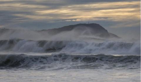
Early European settlement
Late 1800’s to early 1900’s
Terrigal was first settled in 1826.
In 1833, the Wamberal beachside area was granted as freehold land. This was subdivided in 1886 as part of the ‘Gosford Model Farms’. The dynamic nature of the coastline was not recognised at this time.
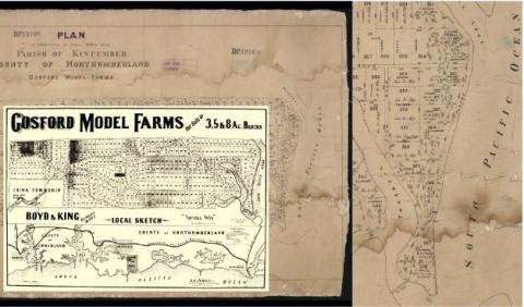
Early 1900’s
Tourism became important at Terrigal late in the 1800’s and early 1900’s. The Terrigal Surf Life Saving Club was formed in 1924. You can see here the prominent erosion escarpment in the densely vegetated Wamberal Beach dunes.
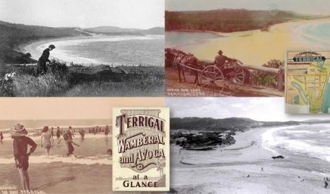
Mid 1900’s
Beachside development towards the southern end of Wamberal can be seen by the early 1940’s (vicinity of Pacific Street). A seawall was constructed at Terrigal by this time too. The Wamberal Surf Life Saving Club formed in 1950.
Foreshore development extended along much of the beach, between Terrigal and Wamberal Lagoons by the late-1950’s to mid-1960’s.
The 1960’s saw a period of significant sand build up on the beach and dunes. Development expanded on the west side of Ocean View Drive, along the edges of Terrigal Lagoon.
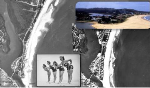
1970’s
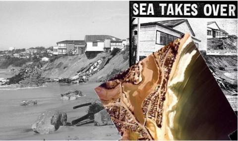
The Central Coast was battered by a stormy period in the 1970’s. Land was lost to erosion from severe coastal storms in 1974 and 1978.
The major storms of May-June 1974 threatened all beachfront properties at Wamberal and damaged one house. The State Emergency Service and the Australian Army placed rocks, sandbags and other materials in front of the erosion scarp. Ad hoc protection works (rock rubble, corrugated iron, concrete walls) were also placed on the beach.
In June 1978, land was again lost to the ocean from major storms that occurred. Erosion resulted in two neighbouring houses being washed away by heavy seas.
Much of the ad hoc protection works remains on the beach today.
1990 to 2000’s
The early 1990’s saw another period of significant sand build up on the beach and dunes. The sandstone block wall was built at Terrigal in 1999. The beach and dunes were mostly steady during the 2000’s also.
Large storms impacted Wamberal-Terrigal Beach during in 1995 and 2007.
To address the ongoing erosion threat, a seawall and sand nourishment protection solution was recommended in 1995 (WBM). This plan was designed in 1998 (WRL) and assessed through an Environmental Impact Statement (EIS) in 2003 (MHL). Council adopted the EIS protection plan in 2004, however funding could not be secured. For this reason, the approved long-term solution did not progress.

2015
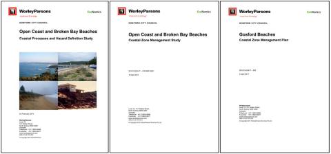
Council investigated the erosion issue and what to do about it, through a Coastal Hazard Definition Study (CHDS, 2015), a Coastal Zone Management Study (CZMS, 2017) and the preparation of a Coastal Zone Management Plan (CZMP, 2017) which was adopted by Council and certified by the NSW Minister.
The Gosford Beaches CZMP outlines actions to address the erosion risks at Wamberal Beach. Sand nourishment and a terminal protection structure (seawall) was again determined to be the best solution to the long-standing issue.
2016
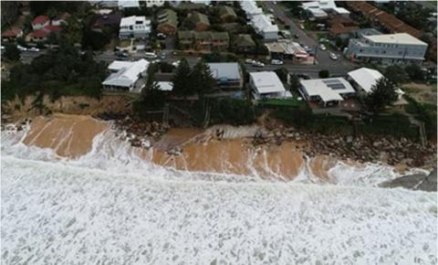
Beachside development was again threatened by a destructive erosion event in June 2016. This was caused by a major coastal storm with an unusual wave direction and king tides. In addition to the erosion impacts, waves washed through Terrigal Lagoon entrance, causing flooding and damage to lakeside properties.
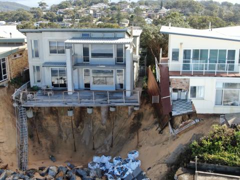
Rock, building rubble and other ad hoc protection materials from the 1970’s was exposed in the Wamberal dunes and on the beach. Some houses were left hanging on the edge of the erosion cliff face.
2018 - 2019
In August 2018 Council successfully lodged a grant application to the NSW Government to receive funding for the investigation and design phase of a preferred long-term (seawall and sand nourishment) solution. The application did not include construction of a seawall.
On 29 January 2019, Central Coast Council resolved to work with the NSW Government to progress designs for a terminal protection structure (seawall) at Wamberal inline with the Gosford Beaches Coastal Zone Management Actions.
May 2020
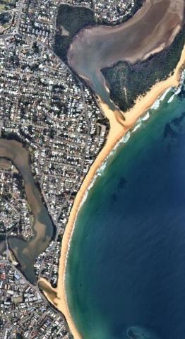
Manly Hydraulics Laboratory (MHL) were engaged to complete coastal assessments and develop concept plans for a long-term solution for Wamberal Beach in May 2020. This included six stages of work:
- Stage 1: Literature Review - to take stock of what is known and identify any information gaps.
- Stage 2: Coastal Protection Assessment - to determine sand movement, beach behaviour and impacts/opportunities around public access and amenity.
- Stage 3: Concept Design Options - for a terminal protection structure (seawall) and sand nourishment, and potential seawall alignment.
- Stage 4: Sand Nourishment Investigation - to help maintain public beach amenity.
- Stage 5: Coastal Monitoring Webpage – to monitor beach conditions.
- Stage 6: Cost Benefit Analysis - to guide development of possible funding models.
Three rounds of community engagement were undertaken to inform the community and gather feedback.
July 2020
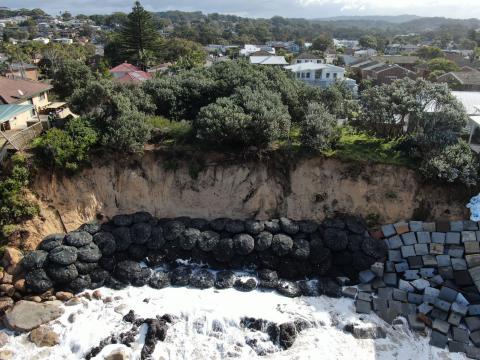
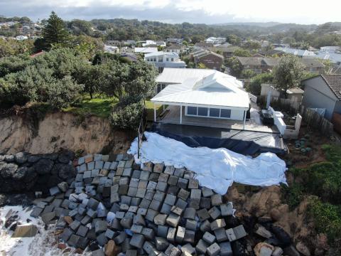
Several large storms impacted Wamberal-Terrigal Beach in 2020. The most destructive erosion event occurred from a major storm in mid-July which impacted numerous properties. Approximately 54 residents were evacuated for their personal safety. Hazardous rubble and debris were strewn across the beach.
A rapid and coordinated erosion emergency response at Wamberal saw the placement of 4,400 tonnes of rock by Council, under emergency orders by the NSW Government appointed Local Emergency Operations Controller. Guided by expert coastal engineers, the emergency rock works ensured that coastal infrastructure was not further damaged by wave action throughout the emergency event. These rock works are not a permanent solution to the erosion issue.
The New South Wales Government established the Wamberal Seawall Advisory Taskforce on the 31 July 2020. A link to the webpage containing the Terms of Reference and meeting minutes has been added to the bottom of the page.
2021-2022
The six stages of work was completed by MHL May 2021
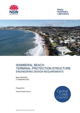
Review of expert technical studies, extensive community consultation and consideration of Council’s role and legislative responsibility in relation to coastal erosion led to the development of the Wamberal Beach Terminal Protection Structure Engineering Design Requirements (EDR).
The EDR’s outline engineering specifications and details such as the minimum footprint, length of construction, material selection, landscaping, and maintenance requirements.
Following public exhibition, the EDR’s were adopted by Council in October 2022 and will now be a consideration in the assessment of any submitted development application seawall structures at Wamberal Beach.
2022-2023
Council resolved in October 2022 to apply the Engineering Design Requirements to private and public land along Wamberal beach. In early 2023 Council joined the development application for whole of embayment coastal protection works and beach nourishment. Council is funding only the elements of the development application that relate to public land. This development application aims to improve whole-of-beach outcomes for the benefit of the community.
2024-2025
Following adoption of the Engineering Design Requirements, three development applications for coastal protection works at Wamberal Beach were lodged: one for each section of the coastal protection works identified in the Engineering Design Requirements. These DAs include protection of beach access ways that are managed by Council on behalf of the community.
Public exhibition of these three DAs has now concluded and they are under assessment by the Hunter and Central Coast Regional Planning Panel (HCCRPP).
Public exhibition of the DA (DA/947/2024) for the middle section of proposed protection works concluded on 6 September 2024. DA/1264/2024 for the proposed northern section concluded on 27 September 2024. DA/1389/2024 for the southern section of proposed works concluded on 21 October 2024. DA documentation is available for viewing via Council’s DA Tracker.
It is anticipated that the HCCRPP will consider the applications in 2025 and that those who made submissions will have an opportunity to present to the HCCRPP as part of the assessment process.
Council has developed a management statement (see link below), in accordance with its Council-related Development Applications Conflict of Interest Protocol to manage potential conflicts relating to Council’s role as a landowner of part of the development and its role assisting the Hunter and Central Coast Regional Planning Panel to assess the application.
-
The Gosford Beaches Coastal Zone Management Plan was prepared in accordance with the NSW Government legislation, and in consultation with the Central Coast community.
The plan was certified by the Minister for the Environment in May 2017 and identifies several key management actions for Wamberal Beach, including:
- TW11: Terminal protection- Council to action review, design and funding of terminal protection structure for Wamberal ,
- TW14: Investigation of sources of sand and determination of the feasibility of beach nourishment for Wamberal Beach,
- TW15: Beach nourishment coupled with a terminal revetment to increase the buffer against storm erosion.
The plan outlines a terminal protection structure (seawall) and sand nourishment as the preferred course of action for managing identified coastal hazard threats at Wamberal Beach.
-
A seawall is one form of coastal protection work. Others include sloping rock walls, dune stabilisation and revegetation. A vertical seawall, combined with sand nourishment, has been identified for Wamberal as the most effective way to both maintain the public beach and protect private property.
-
Any seawall design must be consistent with the Engineering Design Requirements (EDR). The EDR’s highlight the seawall extent and alignment. The current development application being prepared by private beachfront owners is not finalised Once finalised and lodged via the NSW Planning Portal, anyone will be able to look at the proposal and better understand what it will look like.
It is proposed that the seawall will not extend north of Dover Road and does not include the Wamberal Surf Life Saving Club.
-
Feedback received during the MHL Wamberal Beach Terminal Protection and Sand Nourishment - Investigation and exhibition of the Engineering Design Requirements (EDR) resulted in additional criteria for landscaping and aesthetics, which landowners need to address when preparing their seawall design.
One of the key guiding principles outlined in the EDR states: “The seawall is to include landscaping and materials that blend into the coastal environment and be designed to have a reduced vertical relief following the natural cross section of the foreshore.”
Any proposal for seawall at Wamberal Beach will be assessed against the EDR as part of the development assessment process.
-
The Engineering Design Requirements (EDR) outline engineering specifications and details such as the minimum footprint, length of construction, material selection, landscaping, and maintenance requirements. These requirements reflect what the community said was of value and importance during the community consultation period after the draft EDR had been developed.
Following community consultation, Council adopted the EDR on 11 October 2022. These requirements outline specific criteria for the assessment of Wamberal Beach coastal protection development applications in conjunction with the Coastal Management Act 2016.
All development applications for coastal protection works will be assessed against the EDR, along with the extensive other planning requirements during development application assessments. -
Other public land along Wamberal Beach includes Crown Land and land owned by the Office of Strategic Lands and managed by Council. Council continues to work with the NSW Government to implement coastal protection measures.
-
The Wamberal Protection Association proposes to lodge three DAs: one for each section of coastal protection works identified in the Engineering Design Guidelines. These DAs are on behalf of all participating landowners (public and private) on Wamberal Beach that are committed to seeking approval for a seawall and ongoing beach nourishment.
-
To achieve a holistic whole of beach design as recommended in Council’s adopted Engineering Design Requirements, Council decided to use the WPA-appointed consultants following review of the project proposals. This approach provides a consistent design and reduces costs for the component of the seawall on public land that is funded by Council. It also ensures Council’s technical experts have input to the whole of beach design and the proposed design protects public beach amenity and access.
-
Public exhibition for all three DAs (DA/947/2024 for the middle section of proposed works, DA/1264/2024 for the proposed northern section, and DA/1389/2024 for the southern section of proposed works) has concluded. These applications are under assessment, which includes consideration of all submissions made during public exhibition. DA documentation is available for viewing via Council’s DA Tracker.
-
The following DAs for coastal protection works at Wamberal Beach have been submitted. These are separate to the WPA-coordinated DA and Council has no role in these as a landowner:
- DA/60944/2021: 85–89 Ocean View Drive, Wamberal. Status: Under Assessment.
- DA/1452/2024: 35 Ocean View Drive, Wamberal. Status: Under Assessment
- DA/52565/2017: 29, 31 and 33 Pacific Street and 23A, 23B and 25C Ocean View Drive, Wamberal. Status: Approved by Land and Environment Court with conditions.
- DA/2209/2023: 75 Ocean View Drive, Wamberal. Status: Approved by Land and Environment Court with conditions
-
The Landowners Agreement outlines the terms and conditions under which each landowner (including Council) financially contributes to develop the development application. This ensures funds are appropriately allocated and the appointed consultants provide work to a professional standard. It also ensures Council is legally protected and is delivered services required to progress to development application stage. The agreement was developed by external legal experts to ensure integrity, fairness and transparency and that the DA documentation developed best serves Council in its role in the management of public land.
-
If approved, property owners will need to prepare detailed design documents consistent with their approved development consent conditions.
Construction programs will then need to be developed in accordance with any Conditions of Consent as required by the determining authority.
-
If refused, property owners have the following options:
- submit a new DA that addresses the reasons for refusal
- submit an application seeking a reviewing of the refusal
- challenge the determination in the Land and Environment Court
- discontinue the process entirely.
-
Council will not be determining the development application for this very reason. The determining authority will either be the Central Coast Local Planning Panel, or the Hunter and Central Coast Regional Planning Panel. These Panels are made up of appointed independent appropriately experienced members, who consider and determine a range of complex applications in accordance with the NSW legislative framework. The Panels seek input on DAs from the public and provide opportunities for members of the public to speak directly to the Panel as part of the determination process.
-
In accordance with Council’s adopted Council-related Development Applications Conflict of Interest Protocol, Council has developed a Management Statement (see link below) that describes the roles of Council staff in relation to proposed development applications for Wamberal Beach coastal protection works, and how potential conflicts between Council’s role as a landowner for proposed development and as a planning authority are managed.
-
The majority of the seawall is proposed to be located on private land and funded by private landowners. Coastal protection works for private properties (such as seawalls) are subject to a development application process.
The planning process puts the obligation on any proponent to provide the relevant information to satisfy the determining authority that it is worthy of development consent. If the determining authority is not satisfied with the information provided, they may request more information from the applicant, or refuse the application.
Designs must be developed by a suitably qualified coastal engineer and address site specific hazards including coastal and flooding processes and prepared in accordance with:
- Environmental Planning and Assessment Act 1979
- Coastal Management Act 2016
- State Environmental Planning Policy (Resilience and Hazards) 2021
- Central Coast Local Environment Plan 2022
- Central Coast Development Control Plan 2022 and
- CCC Wamberal Beach Terminal Protection Structure Engineering Design Requirements 2022
-
Yes. Council has developed a probity plan and appointed an external probity advisor to manage potential conflicts between Council’s role as an owner of land proposed for part of the seawall and its role in supporting the determining authority in its assessment of whether to grant development consent to the proposal.
This is a familiar process for Council as it often seeks development consent for works on Council land. NSW legislation requires that, while Council planning staff are involved in the assessment of these applications, applications are always referred to an independent determining authority, as part of the probity management process. -
Council has not given or donated money to the WPA or private landowners. In December 2023, Council made a contribution of $100,000 towards the portion of the proposed seawall that is on public land, not for private properties. This is in accordance with Council’s resolutions. The funds cover consultant costs to prepare the development application for Council owned and managed land.
-
Council resolved on 11 October 2022 to: Confirm that coastal protection works fronting Council-owned land at the beach access ways and Wamberal Surf Lifesaving Club also be governed by the Engineering Design Requirements and make provision for the cost of these works in Council’s Long Term Financial Plan. Further allocations of funds toward the project have been made in Council’s Long Term Financial Plan to allow for potential future construction, should development consent be granted.
-
Private owners are paying for DA preparation, construction and maintenance costs for their sections of wall on their land.
-
The reality is, Wamberal Beach is not in a natural state. It is a highly developed environment already with a number of unauthorised ad hoc protection structures in place.. These works consist of emergency and unapproved works and damaged infrastructure, which is unsightly, not designed for long term protection and in many sections extends onto public land.
The current situation at Wamberal Beach comes at significant public cost. Following the July 2020 storms, Council was required to clean up the beach and install emergency protection works at a cost of approximately $2.1 million.
This 2020 coastal erosion event was not rare and has a 50% chance of occurring in any given year.
These expensive emergency works are a public cost and do not serve best environmental outcomes and are inconsistent with community expectations.
-
The “do-nothing” case is the current situation at Wamberal Beach. It involves expensive emergency campaigns, unapproved works, and individual development applications being submitted by homeowners which does not result in a holistic solution. Homes along the beach are exposed to coastal erosion and present safety risks to both their occupants and beach users, as well as risks to the environment.
-
Council does not have the resources to acquire these properties. Buy back alone along Wamberal Beach is estimated at $500 million to $1 billion. Other costs would include demolition of buildings, disposal to landfill and dune restoration costs. The costs are simply unaffordable and unrealistic. In the past 50 years five properties have been purchased by the NSW Government through the NSW Coastal Lands Protection Scheme. Today’s property values along Wamberal well exceed the Scheme’s annual budget of $3 million.
For perspective, the Central Coast Council local government area covers over 80km of coastline, Wamberal is approximately 1.5km. Erosion hotspots are identified at many of our beaches and buy back is even less affordable on this larger scale.
-
Manly Hydraulics Laboratory has calculated that large-scale sand nourishment for asset protection, instead of a seawall, would require an initial 900,000 cubic metres of sand with an ongoing requirement for a further 200,000 cubic metres every ten years. To date, this has not been feasible due to the lack of accessible sand sources.
The current trial at Stockton is investigating whether it is feasible to dredge sand from the ocean and ‘rainbow’ it onto the beach from a barge. At Stockton there is no private beachfront land. Under current NSW legislation it is only possible to use marine sand for a public purpose. This is not the case at Wamberal, where the primary purpose of mass beach nourishment would be to protect private land.
Council has also resolved that any private protection works must be funded by private owners on private land. It would be inappropriate for Council to fund offshore sand for private protection.
Following resolutions of Council, Council has made representations to higher levels of government advocating that mass sand nourishment of areas severely impacted by coastal erosion should be provided to coastal communities.
-
The nourishment costs to compensate for natural recession (which is the same amount required with or without a seawall) are significantly less than if mass sand nourishment were proposed as a standalone solution.
The 2021 MHL Stage 4 Sand Nourishment Investigation investigated the volumes of sand required upfront to offset five different seawall structures. These included:
- Seawall Option 1: Basalt Rock Revetment 252,000 m3
- Seawall Option 2: Sandstone Rock Revetment 270,000 m3
- Seawall Option 3: Vertical Seawall ZERO m3
- Seawall Option 4: Vertical Seawall with Rock Toe ZERO m3
- Seawall Option 5: Tiered Seawall with Promenade 10,000 m3
The vertical seawall options resulted in zero upfront sand nourishment as they are located outside of the active beach profile and only interact, as designed, to address wave run up during a storm event and the beach allowed to naturally recover.
Regardless of any seawall option, 78,000 m3 is required every 10 years to address natural recession (20cm/year) at Wamberal which will incur a cost. This could potentially be provided from marine sand sources, as it would be for a public benefit to maintain the beach, should the trial at Stockton Beach prove successful and transport to Wamberal be financially viable.
-
The Coastal Hazard Management chapter of the Central Coast Development Control Plan 2022 identifies that proponents of development within Coastal Hazard Areas across the Central Coast are generally required to register on title a mechanism that indemnifies Council for damage to, or as a result of, development within designated Coastal Hazard Areas, which include Wamberal beachfront properties.
These agreements on title may take a number of forms, one of which is a positive covenant. Some of the agreements on title require landowners to take action to manage the impacts of their development on adjacent public land. To deliver these actions, development consent is typically required.
The Coastal Management Act requires that the preferred approach to addressing the coastal hazard at a location be identified, documented and agreed, in consultation with the local community, by the Council, an expert panel and the NSW Government. The preferred approach for Wamberal, as adopted in the Gosford Beaches Coastal Zone Management Plan, is a whole of embayment wall and beach nourishment. This is the solution that private landowners and Council (as a manager of public beachfront land and in line with many Council resolutions over many years) are pursuing. This solution is entirely consistent with the agreements on title and has been in development for many years.
-
The Gosford Beaches Coastal Zone Management Plan (CZMP) outlines a terminal protection structure (seawall) and sand nourishment as the preferred course of action for managing identified coastal hazards at Wamberal Beach. The CZMP underwent community consultation and exhibition. Section 1.4 of the CZMP describes that consultation and appendix 6 details how feedback was considered. The CZMP was adopted by a fully elected Council, endorsed by the NSW Coastal Panel and certified by the Minister in 2017.
Coastal protection works for private properties (such as seawalls) are subject to a development application process. Development applications must be prepared, assessed and determined in accordance with the Environmental Planning and Assessment Act 1979 and other relevant legislation, including the Coastal Management Act 2016. Council’s adopted Engineering Design Requirements form part of this assessment framework.
All development applications are submitted via the NSW Planning Portal which includes an exhibition period which allows the community to formally submit a response to the application. Feedback is then considered as part of the determination of that development application. The application will not be determined by Council and there will be further opportunity for the public to address the determining authority, which will most likely be the Hunter and Central Coast Regional Planning Panel. -
Consultation leading to the adoption of the Gosford Beaches CZMP included:
- Ongoing reference and advice from the Coast and Estuary Management Committee and Coastal Sub-Committee between 2010 and 2015
- Terrigal Wamberal Emergency Action Sub Plan consultation exhibited for 42 days between 25 June 2012 and 3 August 2012. Comments received till 3 September 2012, included 11 written submissions and meetings with Coastal Residents Inc. and the Central Coast Community Environment Network
- Coastal Zone Management Study Consultation:
- Draft Coastal Management Study document made available for community review between 15 January and 15 February 2015.
- The Draft Study document was made available in hardcopy format at Council’s Erina, Gosford, Kincumber and Woy Woy customer service centres during normal business hours.
- The Draft Study document was also available in the Items on Exhibition section of Council’s webpage during exhibition.
- Letters sent to 949 property owners identified as being affected by DCP Chapter 6.2 (Coastal Frontage) on 17 December 2014.
- Media Release distributed (week of 12 January 2015)
- Promotion of exhibition in Central Coast Express Advocate via Gosford Connect – general info on exhibition (week of 19 January 2015)
- Media alert (week of 26 January 2015)
- Promotion of exhibition in Central Coast Express Advocate via –specific info on exhibition to include detail/timing of exhibition events (week of 26 January 2015)
- Council held a series of five community forum sessions in early February 2015 for people interested in learning more about the Gosford City coastline and how it is managed. These sessions aimed to gauge community attitude to management options, before the preferred options were presented in more detail via this CZMP. More than 270 people attended these community forums.
- Coastal Zone Management Plan Consultation:
- Draft Coastal Management Plan document made available for community review between 21 August and 2 October 2015.
- The Draft Plan document was made available in hardcopy format at Council’s Erina, Gosford, Kincumber and Woy Woy customer service centres during normal business hours.
- The Draft Plan was also available in the Items on Exhibition section of Councils webpage during exhibition.
- Letters sent to 949 property owners identified as being affected by DCP Chapter 6.2 (Coastal Frontage) on 14 August 2015.
- Emails sent to more than 170 groups and individuals on the project contacts database informing them of exhibition details.
- Public Notices were placed in the Central Coast Express Advocate on 21 August and 4 September 2015 to inform the public of the place at which, the dates on which, and the times during which, the draft CZMP could be inspected by the public.
- Media Release distributed (5 August 2015)
- Promotion of exhibition in Central Coast Express Advocate via Gosford Connect – general info on exhibition (14 August 2015).
- Council held a series of five community drop-in sessions to seek public feedback on the proposed management actions and for residents to have a say and find out more about how coastal hazards will be managed now and into the future. There were 85 people recorded in attendance during these sessions.
- Public Authority Consultation:
- NSW Department of Primary Industries (DPI - Lands)
- NSW Planning & Environment
- NSW Office of Environment & Heritage (National Parks & Wildlife Service)
- NSW Department of Primary Industries (NSW Fisheries)
- NSW Roads & Maritime Services
- Greater Sydney Metropolitan Local Land Services
- Darkinjung Local Aboriginal Land Council
- Guringai Aboriginal Tribal Links
-
The CZMP was adopted by a fully elected Council in 2015. Part of the certification process for the CZMP involved the review of its suitability for certification under the Coastal Protection Act 1979 (current legislation at the time) by the expert Coastal Panel. The Panel considered the draft CZMP in 2016, commended Council on the quality of the document and advised it was suitable for certification, with minor amendments unrelated to Wamberal Beach management. Meeting minutes can be found in the links below.
The CZMP was certified by the Minister for the Environment in 2017 with the amendments required by the Coastal Panel.
-
Part of the certification process for the CZMP involved the review of its suitability for certification under the Coastal Protection Act 1979 (current legislation at the time) by the expert Coastal Panel. During the time of the review, in 2016, Angus Gordon (Chair), Professor Bruce Thom and Professor Andrew Short were all members of the Panel and reviewed the draft Gosford Beaches CZMP.
At the time, the Panel commended Council on the quality of the document and advised it was suitable for certification, including the recommendation for coastal protection works and sand nourishment at Wamberal Beach. Meeting minutes can be found in the links below.
Council is progressing Wamberal Beach actions in accordance with its adopted and certified CZMP. As part of this process, and with funding from the NSW Government’s coast and estuary grants program, Council engaged Manly Hydraulics Laboratory to undertake an extensive body of work to identify the preferred option for coastal protection works. This detailed body of work found that a vertical seawall structure was likely to provide improved public and environmental outcomes compared to the sloping rock revetment contemplated in the CZMP, as it maximised the area available for public beach access and reduced interaction with active beach processes. This led to the adoption of the Wamberal Beach Terminal Protection Structure Engineering Design Requirements (see link below), which identified the engineering specifications, alignment and crest height required for future protection works. These guidelines are outcome focused and do not specify a particular design solution.
Once a development application for coastal protection works is prepared, which will include the proposed design and supporting information about how any potential impacts of the proposed development are to be managed, it will be assessed for alignment with the CZMP and the more detailed work undertaken since the CZMP was certified and will be determined by an independent planning panel. There will also be opportunity for the community and experts to provide submissions on the development application, which must be addressed by the applicant and considered by the determining authority.
-
Flooding in the lagoons is typically associated with a high rainfall event, rather than a coastal erosion event. The level of floodwater in the lagoons is mainly related to the water being held back by the build up of sand on the beach when the lagoon is closed. The potential flood levels in the lagoons without intervention are very high, which can flood many roads and properties, but Council mechanically opens the lagoons with earth moving machinery to help prevent the lagoons from being flooded at very high levels. This is carried out according to an opening procedure.
Flood risks must be addressed as part of any development application.
A seawall design and associated environmental assessment were lodged as part of DA/947/2024 for the middle section of proposed works, DA/1264/2024 for the northern section of proposed works, and DA/1389/2024 for the southern section of proposed works. An assessment of potential impacts will be undertaken as part of the development assessment process. The public have also had the opportunity to review the development application documentation, prior to determination, and provide feedback.
-
Assessment of flood risk is a compulsory part of the development assessment process. It is up to the determining authority to advise whether it considers that the applicant has provided sufficient detail in its flood impacts risk assessment. During the assessment of the development application, the relevant authority will consider the location, footprint and terminal end design of the structure, and whether additional flood risk assessment is required.
Last updated on 7 April 2025